Note: Updated 25 July, 2013 to correct some information about Vadnais’ 2011 Comprehensive Plan.
Vadnais Heights comprises numerous island neighborhoods separated by Ramsey County roads with little or no planning for walking or bicycling. While some people are comfortable walking and bicycling outside of their neighborhood on busier roads with narrow shoulders, many, and perhaps most, are not. Many of those who do venture out also say that riding with traffic scares them and discourages them from riding very often. This is made worse in winter when many of these shoulders are not plowed or plowed inadequately for use by pedestrians or people riding bicycles.
Vadnais Heights’ 2011 Comprehensive Plan acknowledges some deficiencies in its walking and bicycling infrastructure, but also indicates a lack of understanding of the difference between recreational trails and safe, functional bicycle and pedestrian infrastructure that allows it’s average citizens to safely walk or ride to local amenities. Instead of striving for segregated pathways and intersections that are safe and desirable by most people, the plan too often relies on road shoulders that are only comfortable for a minority of citizens, primarily the lycra crowd. Worse, the plan touts striped on-street parking lanes as effective bicycle lanes. These are actually quite dangerous for cyclists as they cause cyclists to swerve into traffic to dodge parked cars and put cyclists in the ‘door zone’ where many have been injured or killed by opening car doors. To their credit they have now installed “No Parking” signs on Arcade and Belland Avenues.
This lack of safe bicycling and walking routes will not serve Vadnais Heights well as increasing numbers of people choose to walk and bike more often for transportation and to make home purchase decisions based on the pedestrian and cycle friendliness of communities.
Every major road in Vadnais Heights should have, at a minimum, a wide, well designed, and well maintained path to allow residents to safely and comfortably walk and bike to local schools, shops and restaurants, or to visit friends. Every intersection should be safe and feel safe for pedestrians and people on bikes.
Here are seven wishes for Vadnais Heights.
Here are seven wishes for Vadnais Heights.
Bikeway or Multi Use Path (MUP) on Koehler Road (Edgerton to Centerville).
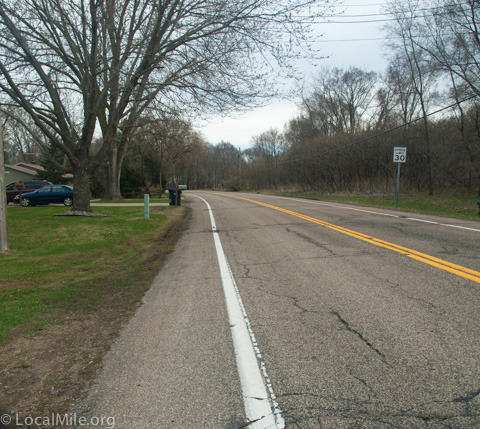
For neighborhoods west of Centerville Rd, the lack of a safe bikeway along Koehler Rd is perhaps the second biggest obstacle (first is the city center itself) for people wanting to walk or ride to Vadnais stores or for children to walk or ride to Vadnais Elementary School. Interestingly, the city of Vadnais Heights touts this in their comprehensive plan as a primary cycle route due to its ‘paved shoulder’. While this road and shoulder may work well for a minority of cyclists, it does not work so well for most Vadnais citizens. The shoulders are narrow (and thus close to car traffic), include many dangerous obstructions, have numerous potholes, and are often littered with debris that can be dangerous and cause flat tires. Shoulders are not bikeways and should never be confused with a bikeway.
Even if the shoulder deficiencies were corrected, we would still be left with, at best, a pseudo bike lane directly next to 35 mph or often much faster traffic which, though relatively safe, feels very unsafe for most people and discourages them from walking or cycling.
Roads like this are also uncomfortable for drivers as they can’t see around corners to know if it’s safe to move over to pass someone walking or riding a bike.
Recommendation: Install a 10-12′ wide multi-use-path (MUP) running adjacent to Koehler, preferably on the north side, that would then run directly next to VH School.
Bikeway or MUP on McMenemy Street & Koehler Road.
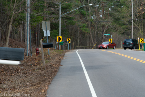
Many of us have had our lives flash before our eyes on our way to or from the Vadnais Lake Trail, particularly walking along the south side of Koehler near the curve from McMenemy. The shoulder is too narrow to be a safe pedestrian or bike lane, especially directly next to 40+ mph traffic. During winter there is often no shoulder available, forcing people to walk in the traffic lane. These road sections also isolate many people living in neighborhoods such as Colleen Drive, Woodview Ct, Bear Ave, and Brunet Ct.
Recommendation: Extend the MUP on the northern end of Edgerton south and continue along the south side of Koehler. A temporary solution for what is perhaps the most dangerous issue would be a trail leading from the corner of the water works property next to xxxx Koehler Rd that would allow people to access the Vadnais Lake trail without being endangered by cars coming around the turn (photo above).
Vadnais Center District & County Road E.
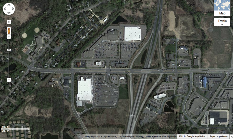
This is one of the more uninviting retail areas in the northeast metro for pedestrians and cyclists. There are a few sidewalks but they are too narrow to act as safe multi-use paths (not to mention that they are also illegal for cyclists to ride on). There are limited and poorly placed sidewalks in the parking lots that make up the bulk of the acreage. Crossing County Road E is quite unpleasant with the need to cross as many as eight lanes of traffic, and without appropriate pedestrian/bike refuges. If you’re not young and quick, you likely cannot make it across in the time allotted by the crossing signals. In the one place where there appears to be a refuge (though perhaps poorly designed), the striping indicates that pedestrians should walk around it rather than use it. All together, these elements discourage rather than encourage walking or cycling to Vadnais City Center.
Even though technically illegal, many people do ride their bikes on the sidewalks and Ramsey County Sheriffs usually tend to look the other way, given the option of dodging multiple lanes of cars driving 40+ mph on County Road E. The frontage roads and parking lots seem to be designed for car speed rather than for the safety of people walking or riding bikes.
Some residents have mentioned that they prefer to ride to North Oaks Village Center, further away and along busy Hiway 96, rather than Vadnais restaurants due to the much better cycling and pedestrian infrastructure. More on Vadnais City Center in a separate post.
Bikeway or MUP Along Edgerton Street.
Edgerton is another road that isolates many of the people who live in its neighborhoods and presents an obstacle to their safely walking or riding to local destinations. Edgerton also presents an obstacle for anyone wanting to ride to downtown St Paul. For nearly all residents of Vadnais Heights, Edgerton is the best cycle route to downtown and to hundreds of destinations between Vadnais and St Paul. The good news is that the Met Council appears to recognize this and Edgerton is included in its future plans for development of major cycling corridors. Whether it remains a priority and becomes so for Ramsey County is yet to be determined.
Remove Unnecessary Stop Signs From The Centerville MUP.
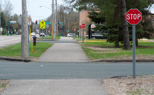
Those riding bikes on a multi-use path should generally follow the same traffic pattern as vehicles on adjacent or parallel roadways. This is less confusing and safer for everyone. Vehicles leaving or entering parking lots, or side roads such as Nature View Trail, should stop prior to the MUP crossing and should always make sure there is no traffic from either direction on the MUP and from appropriate vehicle lanes before proceeding.
The stop signs along the Centerville MUP are inconsistent with the majority of MUPs in the U.S. and world and are against AASHTO (the U.S. traffic engineers bible) guidelines. Expecting a cyclist or pedestrian to stop for each and every one of these stop signs is unrealistic and few will do so – not a lesson we should be teaching, particularly to the many children who blow through these signs. Also, cars not stopping before the MUP will instead stop in the MUP which blocks it entirely. Fortunately, most drivers recognize the ill placement of these signs and stop themselves to wave cyclists through. It is interesting that drivers intuitively recognize how this should function vs how it is set up.
While most drivers do stop prior to the MUP despite the stop signs that infer they do not need to, about 1 in 5 do not, and this creates danger for pedestrians and cyclists. Similarly, a driver seeing these stop signs here may assume that all MUPs are patterned like this and that vehicles always have the right-of-way when crossing MUPs. This is not the case and thus makes these drivers a significant danger to all pedestrians and cyclists on all MUPs.
Additionally, the MUP material, color, and if possible, grade should extend across the drive to help advise drivers of the presence of the MUP.
Note: All path users should still always exercise caution when crossing driveways or side-roads.
Paths or Sidewalks?
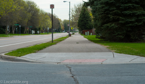
Vadnais Heights, like many U.S. cities, has a bit of a path/sidewalk identity crisis. Sometimes it’s difficult to know if something is a path or a sidewalk (according to the city, asphalt vs cement is not an indicator). Other times, elements of sidewalks (photo above) are placed in what otherwise appears to be a path, making it difficult and dangerous for those riding bikes.
While completely segregated and specifically designed motor vehicle, bicycle, and pedestrian ways are the ideal and are the standard in Scandinavia, The Netherlands, and many other places, they may be hard to justify in cities such as Vadnais Heights (except perhaps for Vadnais Center District). Multi-Use Paths, or MUPs, shared by pedestrians and bicycles, are a moderately good interim solution – if they are designed, implemented, and maintained correctly.
Paths should be wide enough to accommodate all current and future users safely. This includes both a wide paved area and safe width, clear of obstructions such as vegetation, signs or mailboxes. Paths should be smooth and crossings should be clearly indicated where necessary so that cars are aware of the path and aware of where to stop.
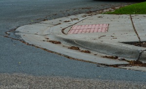
The photos above and right show the path along Belland Ave where it meets a side road. This design is both very uncomfortable for bike riders to joltingly humpity bump over and creates a danger of crashing as a result of these bumps, the dot rippled anti-skid surface (red), and sudden narrowing and mis-alignment from the full width (the narrow area in the middle with no curb above).
Because of this design, many people riding bikes along Belland Ave do not use the path and instead ride in the street or do not ride at all. The good news here is that Belland Avenue is generally a low volume street; however, it also sees a number of quite fast drivers which do make many Vadnais citizens nervous.
Properly implemented paths should continue full width where they meet adjoining roads. Ideally, paths should continue across intersecting minor roads at path level resulting in a bit of a speed table across the road and a change in material that together help to make drivers aware of the path.
Perhaps the most dangerous element for pedestrians and for those riding bikes in the U.S., on paths or road surface, is vehicles making right turns without stopping and looking. A tabled crossing helps to reduce incidents of cars, including right-turning cars, hitting and injuring pedestrians and people on bikes, has become the standard in Sweden, and is quickly spreading to other countries. Where a tabled crossing is not possible, the transition from the path to the road surface should be as smooth and gradual as possible without a jarring bump and if possible the path material should continue across the road surface as an indicator to drivers of the path.
A Complete Streets, Pedestrian, and Cycling Plan. Vadnais Heights has no Complete Streets plan and minimal and sometimes misguided pedestrian and cycling plans. Without such a plan and good implementation, Vadnais Heights risks being left behind other cities. Check out North St Paul (Living Streets), and Northfield (Complete Streets), for a couple of examples.
As a part of developing this comprehensive plan, the mayor, city council members, city administrator, city planner, and others should routinely walk and bike to work/city hall to better understand the problems that pedestrians and cyclists face.
