Update (23 Jul, 2013): A crossing has been added across Lexington just north of the 694 ramps. This will be good news for Land O’ Lakes folks and anyone who ventures down the path on the west side of Lexington without realizing that it’s effectively a dead-end.
They are also exploring the addition of refuges.
They are exploring adding No Turn On Red signs at Lexington & F though agree that these are not always effective with U.S. drivers. They are also concerned about how this might delay motor traffic.
All path/pedestrian ramps will be full path width. I assume this means that cyclists can safely ride to street level at any point across the ramp. No word yet on dealing with the jarring bumps of current designs or with anti-skid rumbles.
More to come.
—-
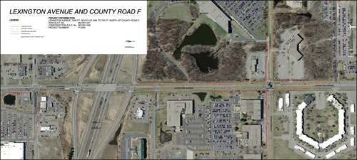
Ramsey county plans, in 2014, to reconstruct Lexington Avenue between Red Fox Rd (just south of 694) to just north of it’s intersection with County Road F, as well as nearby portions of County Road F. Expanding the Lexington & F intersection is the primary driver of this project.
Click for latest project plan.
They have included some pedestrian and cycling infrastructure, but the current plan still leaves this corridor dangerous for both pedestrians and cyclists, particularly at the Lexington & F intersection that is the core of this project. Given the additional lanes, potentially higher motor vehicle speeds, lack of crossing refuges, and other elements, this corridor may be more dangerous for pedestrians and cyclists after this project is complete than it is currently.
Shoreview has some of the best cycling and pedestrian infrastructure in the Twin Cities (and the U.S.). It will be a shame if this project does not continue this leadership.
Below are some concerns with the current plan as well as some possible recommended solutions.
Concerns:
The primary problems Bicyclists encounter along this corridor are:
– Motorists entering or leaving driveways or minor roads not stopping or looking for pedestrians and cyclists on the path. Gramsie perhaps the most dangerous though the driveway to Land O’ Lakes on the east side of Lexington can be problematic as well.
– Right turning motorists (mostly from Lexington) not slowing, stopping, or looking when people are in or entering marked crossings.
– Similar for left turning motorists though this happens far less often.
– Crossing buttons that are difficult to access and often ignored by cyclists because of this.
– Timing of signal cycles causing pedestrians and bicyclists to wait a considerable time. This is particularly problematic when having to make two crossings such as for a right or left turn.
– Transitions between the path and roadway that are not full path width, have a jarring bump when bicyclists hit the reverse slope gutter, and include a truncated dome matt.
– Congestion on the path.
Lexington & County F Intersection
Intersections are one of the more dangerous places a pedestrian or cyclist encounters and may account for the majority of injuries and deaths.
Under the current plan, pedestrians and cyclists will be required to cross five to seven lanes of heavy and high-speed traffic with no refuge in the middle. Second, due to wide radius corners, cars and trucks turning right are encouraged to do so at high speed, often without stopping, and without regard to pedestrians and cyclists crossing the road.
Potential solutions:
Underpass. The ideal with an intersection such as this is complete segregation of motorized and non-motorized traffic with underpasses or bridges. An underpass is generally the preferred option for cyclists since it requires less grade change (cyclists require less headroom than semi trucks). While not necessarily an expensive solution, there is at least one possible problem. The grade of the path on the north side of the tunnel underneath County F could be quite steep. The intersection may already be raised enough to mitigate this though I do not know at this time. Otherwise, a chicane or loop in the northeast corner could potentially resolve this. An underpass would eliminate the real and perceived danger of this intersection and encourage more people to walk and bike in this area.
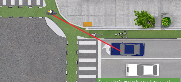
If crossings must remain at-grade there are a few things that can reduce the real danger somewhat and improve the feeling of safety. 1) Moving the stop lines back 10 – 16 feet and insuring that there are no obstructions between drivers and waiting pedestrians will allow drivers to more easily see pedestrians and bicyclists before making a right turn. In the diagram below of a cycle track you can see how this helps to keep pedestrians and bicyclists within the natural field of view of the driver and also within the front windshield instead of hiding pedestrians and cyclists behind the windshield column. This has other benefits such as making it more clear to drivers that someone wants to cross and in which direction, eliminates or reduces the problem of pedestrians and bicyclists cutting the corner when they are using two crossings to make a left turn, and helps to relieve pedestrian and bicycle congestion since it separates those crossing N-S from those crossing E-W.
Note that our current designs have pedestrians and bicyclists crossing together and in the apex of the turn, perhaps the most dangerous place possible. Also, right-on-red is the one maneuver we allow on our roadways that encourages drivers to look in the opposite direction of where they are driving and we do this at the most likely time a pedestrian or bicyclist will be in their path (and this is why the U.S. is the only industrialized nation I’m aware of that still allows right-on-red).

2) Protected right and left turn signals that legally disallow vehicles from making turns across pedestrian and cyclist paths when the pedestrians and cyclists have right-of-way. 3) Refuges large enough for several pedestrians and bicyclists might help. As well, light timings should allow pedestrians and cyclists to cross as soon as practical. If people are delayed too much and in particular, if they are delayed when vehicles traveling in the same direction are not, they are more likely to cross against the signals.
Additional issues for this and other intersections:
Tabled Corner. The corners of the intersections in this project are quite a wide radius (in order to allow large trucks to more easily navigate them). This design however also encourages cars and trucks to make much faster turns, often without stopping or looking, that greatly endanger people in the crossings. One potential solution is a “tabled corner” that raises the inner portion of the turn a few inches, similar to a speed bump—just enough that cars and trucks will slow down prior to turning to either go around it or go over it.
Maintain Full Path Width Thru Curb Cut. The curb cut transition from the path to road surface should be aligned with the path as best as possible and be the full width of the path. The typical transition often used, that narrows considerably as it approaches the road surface, can be quite dangerous for cyclists and pedestrians.
Avoid Jarring Bumps at Curb Cut. The path to road surface transition should be as smooth as possible. The design often used in Minnesota creates a quite jolting bump that is both uncomfortable and dangerous for bicyclists.
Crossing Button Placement. Crossing button placement is critical if we want cyclists to use them. A button needs to be placed along the path where cyclists can safely access them without getting off of their bike and without having to backup to realign themselves for crossing. The best location is on the right side of bicyclists forward path of travel. In some cases, secondary “ride-by” buttons placed along the path prior to the intersection may help to resolve problems of ADA placement requirements. If adjacent traffic currently has a green, this would also allow the signal system to give the bicyclists an immediate crossing along with other vehicle traffic before the bicyclist stops. Ideally this might also include buttons for coordinated left or right turns as appropriate.
Truncated Domes. The truncated dome anti-skid pads can be uncomfortable for all cyclists and dangerous for some. They are also beneficial to pedestrians and critical for the sight impaired who use them to know when they have arrived at a crossing. One option is to have separate crossings for pedestrians and bicycles (not a bad idea anyway) with anti-skid for the pedestrians and not for cyclists. Another possible option is to place the anti-skid only along one side of the transition so that it’s available for pedestrians but allows cyclists a safer option.
Some of these design elements for bicyclists, while seemingly only convenience features, have safety aspects as well. A pedestrian or cycle path that is very inconvenient or uncomfortable to use will encourage people to choose less safe alternatives, such as riding in the roadway or not waiting for a crossing signal. While faster bicyclists should be in the road, most bicyclists should not.
Lexington and Red Fox Road intersection
Pedestrians and cyclists from north of 694 wanting to access retail and restaurants southwest of Lexington and 694 will be required to cross six lanes of heavy and often very fast traffic near Red Fox Rd. This intersection is not being reconstructed as part of this project, though an additional turn lane is being added. Similar to above, the ideal solution may be an underpass for crossing Lexington Ave, somewhere near Red Fox Rd. Alternatively, the same treatments as above for Lexington and F, such as moving the stop lines back and tabled corners, could significantly improve the safety of this intersection.
The best solution though, might be a pedestrian and bicycling bridge over 694, west of Lexington, that allows pedestrians and bicyclists to also avoid the entrance and exit ramps which can also be dangerous. The path on the west side of Lexington would turn west just south of the Land O’ Lakes driveway and before the westbound 694 entrance ramp, cross over 694 and the entrance ramps, and then turn back east towards Lexington near Perkins or perhaps continue on the west side of Perkins which might also provide a safer crossing of Red Fox Rd.
Lexington & 694 Eastbound Entrance Ramp
Similar to above there is a problem of cars not stopping and taking the turn too fast without looking for pedestrians and cyclists.
Minor Road and Driveway Entrances

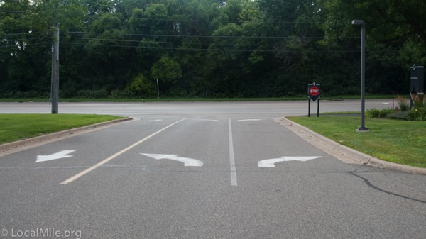
Minor road, driveway and parking lot entrances pose a significant safety hazard as well. This is primarily from drivers not looking for people on the path and not stopping for them. This is likely due to little or no indication for the motorists that the path exists and has right-of-way (above).
The pedestrian and cycle path running parallel to Lexington and crossing these less trafficked entrances should continue across these as one element in color, material, and grade. The driveway or road should meet the path, not the other way around.
A tabled crossing, with the bicycle and pedestrian crossing remaining at path height, about 3″ above the vehicle lane, has proven to work well elsewhere to alert motorists to the existence of the path and to get them to stop before crossing (which they are legally required to do). The path remains at a constant height, constant paving material, and color (or is paved or painted green). The road or driveway rises to meet the path. Typically the ramp up to path height is quite shallow (18-24″ in length) so that it does not pose a problem for snowplows. This has the added benefit of significantly reducing snow and rainwater buildup in the crossing which improves safety and comfort for pedestrians (particularly disabled folk) and bicyclists.
This should be the design anywhere motor traffic on the adjacent parallel roadway, such as Lexington, is uncontrolled (not required to stop).
Lexington & Gramsie
The current plan has the path crossing at perhaps the most dangerous place, where drivers leaving Gramsie are looking to their left for an opening in traffic rather than looking where they are driving. Moving this crossing back to before the dividing median might be a safer location.
And, similar to other uncontrolled intersections, the path should continue as one element in color, material, and at path grade when it crossed Gramsie.
Path Segregation and Width
The shared path on the east side of Lexington gets the most traffic and will continue to do so due to numerous desirable destinations on this side and the only crossing over 694 being on this side. Ideally there should be two separate facilities; a pedestrian sidewalk and a two-way cycle track. During spring, summer, and fall this shared path can become quite congested, particularly during mid-day, and will become more so in the coming years as more people choose to walk or bike to lunch or to run errands. As an alternative, widening this path will provide more space and reduce conflicts during times of congestion.
