(Note: This is a draft being very slowly written by several people. Please comment below if you notice errors that should be corrected)
Discussions of bicycle lanes, tracks, paths, and boxes can get quite confusing. Even for those of us who spend considerable time doing so. The following will hopefully provide a good overview for all of us and help to avoid some confusion.
Much design and terminology is rooted in geographic location, primarily The Netherlands. Before we delve in to all of the types of cycleways then, let’s briefly look across the ocean. The Netherlands are widely regarded as the gold standard when it comes to designing for bicycling. To steal a bit from Winston Churchill, The Netherlands has the worst bicycle infrastructure there is, except all of the others.
There are more bicycles in The Netherlands than there are people and about twice as many bicycles as cars. Between a third and half of the population rides to work each day and nearly everyone rides a bicycle for all shorter trips of 1 or 2 miles each way and many for much longer trips. The Netherlands is the safest place in the world to ride a bicycle and is also one of the safest for walking or driving.
It wasn’t always this way though. Through the 50’s and 60’s they were on the same congested car-centric trajectory as the U.S. and other countries. In the early 70’s, noting the fatalities caused by drivers, they made a very conscious decision to encourage bicycling. The result has been quite dramatic and succesful for motorists, pedestrians, and bicycle riders.
If you ride a bicycle in The Netherlands today, you will notice a few things about their facilities—speed and volume of motor traffic dictates the level of separation between motor traffic and bicycle riders. Or the space available for appropriate segregation dictates the speed and volume of motor traffic allowed.
- Bicycles do indeed Share The Road with cars (rarely trucks though), but only on local access roadways with a speed limit of 18 mph or less. Many residential roads have a maximum speed of 13 mph. Also, if the ratio of cars to bicycles is above 1:2 then they will install protected bikeways.
- Above 18 mph or a higher volume of cars and the roadway will include some form of bicycle specific facility; a bike lane, cycle track, or side path. Cycle tracks are similar to bike lanes but are physically separated from motor vehicle traffic. In the US these are often referred to as Protected Bikeways. Note that The Netherlands mostly no longer builds painted bike lanes and a cycletrack is the minimum facility that will be built.
- Above 25 mph, roadways will have cycle tracks (protected bike lanes).
- Above 30 mph, roadways will usually have cycle paths. With every 6 mph (10 kph) increase in motor vehicle speed there is a corresponding increase in the the buffer between the roadway and the bicycle path. For instance, a 40 mph road would have a buffer of 5 – 8 feet minimum while a 50 mph road would have a buffer of 15 – 20 feet. The wider buffer is for the comfort and safety of people riding bicycles and to provide enough separation from traffic noise that a conversation can be had.
This all makes riding in The Netherlands quite pleasant and safe. In photo’s of The Netherlands you will notice that nobody wears a helmet. When asked why, they simply ask “for what purpose”? Bicyclists in The Netherlands suffer a head injury about once in every 900 lifetimes, less than 1/8 as often as someone in the US.
OK, now to some terminology:
Types of Cycleways
Any street, lane, path or track intended for transportation by bicycle and marked for such by paint or signs is a cycleway or bikeway. A street where bicycles may legally ride but is not specifically marked would generally not be called a cycleway.
There are three key portions of a bikeway; the path, minor junctions along the path, and major junctions. Each is important.
The following are all different elements of and types of cycleways:
Note: This symbol denotes facilities that work well for all users. In other words, from 8 to 80, including disabled. Most are based on Dutch standards and are the only facilities being built in The Netherlands. Facilities without this logo are those intended primarily for vehicular cyclists or other more experienced bicycle riders.
——-
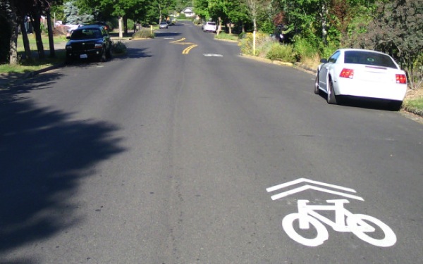 Sharrows are painted symbols on the roadway to tell motorists that the roadway is shared by drivers and bicyclists and to indicate approximately where bicyclists should ride. Sharrows have come under considerable criticism for not providing any real benefit and concerns that they make bicycling more dangerous because some drivers assume that bicycles are not allowed on streets without sharrows.
Enhanced Shared Lane is a street shared by bicycle riders and motor vehicles and designated as such with paint or signs. Most will include Sharrows.
Bicycle Boulevard is a street shared by bicycle riders and motor vehicles and designated as such with paint or signs. It is a ‘step up’ from an Enhanced Shared Lane. On a Bicycle Blvd the bicycle riders have right-of-way, motor vehicles are considered guests, and efforts are made to reduce through traffic and speeds.
Cycle Street is a street shared by bicycle riders and motor vehicles. Bicycle riders have right-of-way and in many cases motor vehicles may not pass bicycle riders. Maximum speed is 18 mph though some will be 13 mph and others a ‘walking pace’. These are specifically designed to not allow motor vehicle ‘through traffic’ via Filtered Permeability — using short street segments, blocking longer streets to disallow through traffic, or using opposing one-ways. These are done on a neighborhood-wide basis to eliminate rat runs. Travel by motor vehicle is usually limited to about 1/8 mile while people walking or riding bicycles can travel much longer distances.
A Cycle Street differs from a U.S. Bicycle Boulevard or Enhanced Shared Lane primarily in not allowing through motor traffic (vs only reducing through traffic), lower speeds, and not allowing motor vehicles to pass bicycle riders. Cycle Streets usually use 8-9′ lane widths which help to reduce motor vehicle speed and make passing difficult. This is the standard for residential streets in The Netherlands.
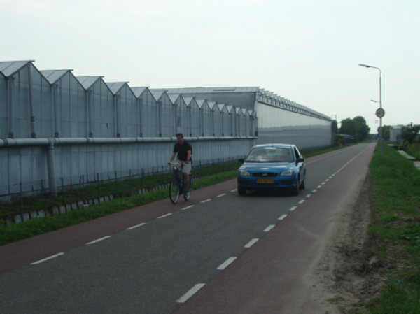
 Advisory Bicycle Lanes are bicycle lanes that can be shared with cars. Generally, cars drive down the center of the street, bicyclists on either side in the bike lanes. If a second car comes in the opposing direction then one or both vehicles may use the advisory bike lane to pass. Bicyclists always have the right-of-way. Advisory bike lanes can work somewhat well on low traffic low speed roadways. Cars are never allowed to park in an advisory bike lane nor should there be parking beside it due to the danger of dooring. (Photo: S. V. D. Oyeweg in Pijnacker from http://wiki.coe.neu.edu/groups/nl2011transpo/wiki/e2b66/.)
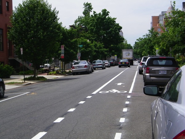 Bicycle Lanes are painted lanes on the roadway dedicated to bicycle travel. They provide no physical protection between motor vehicles and bicyclists. In Europe they are or were considered appropriate on roadways with speeds of less than 25 mph. The Netherlands has now discontinued the installation of any new bicycle lanes and now utilizes cycletracks (or protected bike lanes) only. Note that this bike lane is in the ‘door zone’ which is considered quite dangerous. The above could be safer and more comfortable if the bicycle lane were on the right side of the parked cars effectively making it in to a protected bicycle lane (and without requiring any more space) Click for more and why we may not want unprotected bike lanes.
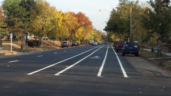 Buffered Bicycle Lanes have a painted buffer between the bicycle lane and motor vehicles for an added bit of safety. This helps to keep motor vehicles 3′ from bicyclists and may help protect against being ‘doored’. A buffered bicycle lane should always have a buffer between the bicycle lane and traffic lane and sometimes, as above, have a buffer between the bicycle lane and parked cars. (Photo: Park Avenue, Minneapolis, MN by Paul Mogush)
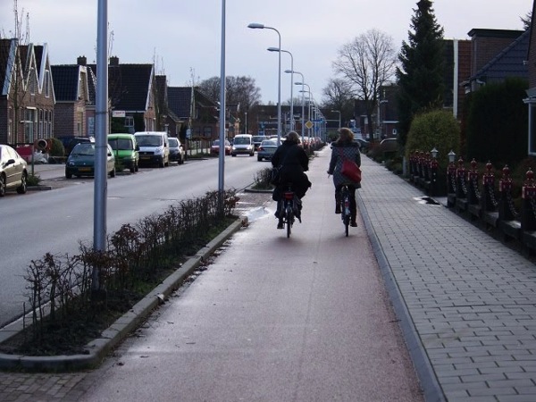
 Cycle Tracks (Protected Bikeways or Protected Cycleways) have a physical barrier between motor vehicles and bicycles. This barrier may be a cement curb, planters, or parked cars. Bollards are also an option though not as effective and do not prevent debris from the traffic lanes or the splush wake from passing vehicles from entering the cycleway. Cycle tracks greatly increase real and perceived safety. In Northern Europe, cycle tracks are used on roadways with speeds of 25 or 35 mph. (Photo: Cycletrack in Amsterdam, By David Hembrow)
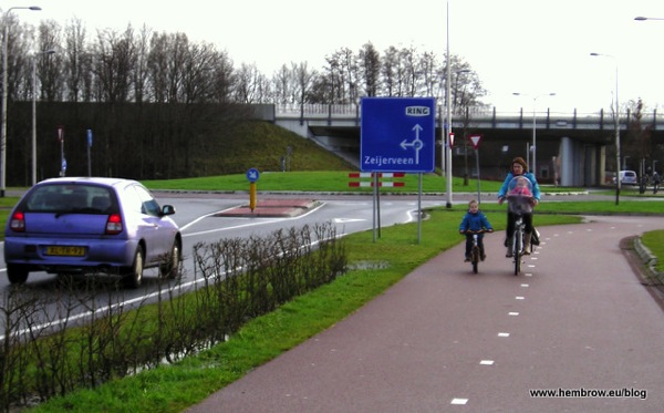
 Cycle Paths (or Side Paths) are paved paths that are separated from motor vehicles by a buffer of grass or other vegetation and sometimes a physical barrier such as curbs or trees. The width of the separation determines the enforced speed of motor vehicles. (Photo: David Hembrow)
Side Paths may be two-way (as above) though are usually one-way and on each side of the roadway. Bike Lanes, Buffered Lanes, Protected Lanes, and Cycletracks are nearly always and should always be one-way and on the right side of motor traffic which is safer, particularly at junctions, and more comfortable.
Cycle Paths may also be completely separated from a motor vehicle corridor. Since bicycles take little room and are very quiet these can provide routes that would not be appropriate for motor vehicles. The Mid-Town Greenway and Gateway Trail are local examples (though these are also MUPs which you will rarely see outside of the U.S. where bicycling and pedestrians are usually given separate and dedicated facilities).
 Multi-Use Paths (MUPs) are similar to cycle paths but allow multiple uses so will often include people walking, riding bicycles, inline skaters, and disabled. These can be relatively safe if all users obey proper path etiquette. If traffic on the path increases then users should be separated on their own paths. The Gateway Trail and the MUP along Hodgson Rd in Shoreview are examples of MUPs (and both should likely be segregated).
This is the one place where I differ from most in that I consider MUPs a good and viable alternative while most people will say that there are too many conflicts between people walking and riding bicycles.
Multi-Use Trails (MUTs) are unpaved trails for multiple users. In general transportation use a Path is paved and a Trail is unpaved.
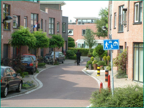
 Woonerf (or Living Street) is a street designed for shared use by multiple users including pedestrians, children playing, bicycles, and motor vehicles. A Woonerf will usually have a speed limit of 15 to 20 kph (about 12 mph) or sometimes a ‘walking pace’ denoted by a sign of people walking. (Photo: StroupCondoBlog)
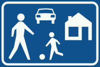
A woonerf will not allow through motor vehicle traffic. For motor vehicles they are a dead-end or cul-de-sac and intended for limited local access only. They will usually allow through walking or bicycling however, often referred to as permeability. For example, two culs-de-sac connected together by a walking and bicycling path would be similar to a woonerf. People can walk or ride between them, but cars cannot. This significantly reduces motor vehicle traffic and speed resulting in a much safer and more pleasant neighborhood.
Woonerfs come in many varieties such as the mews above, a street lined with shops, or a residential street with front yards and gardens. The Netherlands has largely discontinued the building of traditional Woonerfs with most residential streets now a cycle street shared by cars and bicycles with a speed limit of 18 mph.
Complete Streets are streets for everyone. They are designed and operated to enable safe access for all users. People of all ages and abilities are able to safely move along and across streets in a community, regardless of how they are traveling. Complete Streets should make it easy to cross the street, walk to shops, and bicycle to work. They allow buses to run on time and make it safe for people to walk to and from train stations (from http://www.smartgrowthamerica.org/complete-streets/complete-streets-fundamentals).
Typically a complete street will include a sidewalk on each side for pedestrians, a cycletrack on each side for bicycle riders and disabled on mobility scooters, and motor traffic lanes in the middle. Complete Streets are effectively a fancy promotion for Dutch style infrastructure though no implementation has yet attained anything comparable to a Dutch standard.
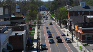
Note that the photo at the top of the Complete Streets page (and at left) is actually a quite poor design for a bicycle lane because it places riders next to the drivers side of parked cars. This increases the danger to bicyclists of being ‘doored’ by drivers exiting their vehicles or of being hit by drivers entering or leaving a parking space. Instead the bike lane and car parking should be reversed so that the bike lane effectively becomes a cycle track between the parked cars and sidewalk.
Minor Junctions
Minor junctions are places where a cycleway intersects a minor motor traffic junction such as a residential driveway, parking lot entrance, or minor street. These can largely be categorized as Dutch and everything else.
 Dutch. Minor junctions in The Netherlands are distinguished by two key elements; grade and right-of-way. Cycleways in The Netherlands are designed to provide a safe, comfortable, and efficient experience. Curb cuts like we use and other jarring bumps are both a safety hazard and uncomfortable so a bicycle path will be designed for a relatively smooth grade across all minor and most major junctions to avoid these.
Right-of-way is critical to these minor junctions. If bicycle riders have the right-of-way (nearly always) then the path color, material, and grade will continue unbroken. The crossing drive or street will rise or descend to path grade. This provides a very critical message to motorists that there is a bicycle path and that it does have right-of-way. If there is significant motor traffic then the bicycle path will be marked with paint and either motor traffic or bicycle traffic given ‘sharks teeth’ to indicate who has right-of-way.
Other. Outside of the Dutch style designs above, which are seen in numerous countries, not just The Netherlands, are a hodgepodge of designs or non-designs. Some function OK, most do not. In some cases there is considerable ambiguity over who has right-of-way which is quite dangerous and in many there is no indication of the existence of a cycleway which also puts bicycle riders in danger.
Major Junctions
Major junctions include most roundabouts as well as intersections with traffic lights. Designs can largely be grouped by Dutch, Copenhagen, or Vehicular (American). Briefly:
 Dutch Junctions. The Dutch approach to junction design is for a very high level of safety and efficiency for all users; motorists, bicycle riders, disabled, and people walking. They believe that this is best accomplished through separation and that separation can be accomplished in both time and space.
Time separation is through signal timing such as motor traffic never being allowed to cross a bicycle path when bicycle riders may be present. Here is a good example of a typical Dutch junction as explained by Mark Wagenbur. Simultaneous Green is another method of achieving this.
Physical separation includes reducing or eliminating space in common. An underpass (tunnel) for bicycle riders is the preferred method of accomplishing this. Bridges or overpasses are also an option.
Copenhagen Junctions. Copenhagen has traditionally taken an approach that mixes bicycle and motor traffic. This is sometimes a bit less costly than the Dutch approach and has worked relatively well in Copenhagen. Its success in Copenhagen is attributed to the much lower speeds of motor traffic, lower traffic volume, and a higher degree of consideration for others that may not exist in other cultures. They also have many fewer trucks.
Copenhagen junctions are perhaps most typified by a protected cycletrack leading in to (or mixing in to) a right turn lane where bicycle riders going straight mix with motorists making right turns. The ‘Copenhagen Left’ is another example. Lessons From Copenhagen provides a very good overview.
Vehicular Junctions. Vehicular junctions are those that include no special bicycle facilities or facilities only for vehicular cyclists, people riding bicycles along with motor traffic.
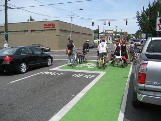
Bike Boxes are boxes painted on approaches to intersections. The intention is to give vehicular cyclists a head start going through signalized intersections. In practice these are not considered safe for bicycle riders and are frustrating for motorists.
 Simultaneous Green. This is a signaling program that gives a red to all motor traffic and a green to all bicycle traffic. Bicycle riders may proceed in any direction all at once, including diagonal. These work quite well because bicycle riders can negotiate with each other as they intersect to avoid collisions. Simultaneous Green intersections have proven very safe and very efficient for all users; bicycle riders, disabled, people walking, and motorists.
Other Terms:
Vehicular Cycling is a term coined by John Forrester in his campaign for all bicycles and cars to share the road equally. In other words, bicyclists should ride as a vehicle. Two key problems with this are that; we have not yet figured out how to keep drivers from killing other people in cars (over 30,000 in the U.S. each year) so certainly will have difficulty keeping drivers from killing people on bicycles, and, most rational people are not comfortable riding a bicycle among 4000 lb motor vehicles.
There is also a paradox built in to vehicular cycling in that if it were actually successful and many people did it then we would have massive congestion problems of cars lined up behind people riding 11 mph on their bicycles. We have problems now with very few vehicular cyclists, imagine if there were 10 times as many (which would get us to about 1/3 the number of bicycle riders as The Netherlands).
Vehicular cycling is to some extent a good coping mechanism for situations where a safer segregated facility is not available. It should be noted that there are somewhat two types of vehicular cycling; American, as promoted by John Forrester, and European, as practiced by bicycle riders in Europe. The primary difference is one of consideration for others. European drivers have a greater degree of consideration for others than typical American drivers so European bicycle riders can more safely ride to the right than American riders who may need to ‘take the lane’ far more often.
Vehicular cycling is appropriate for those riding over about 20 mph and training for a race or other fitness. In most countries, vehicular cycling on the roadways is limited when it will conflict with significant motor traffic and where there is a safe cycleway available. Those in The Netherlands and elsewhere who race or do training rides for fitness say that this has not been a problem.
 Segregated Bicycling is somewhat the opposite of vehicular cycling. This is what you see in The Netherlands and increasingly in other countries such as Denmark, Sweden, Finland, Germany, and elsewhwere. With segregated bicycling, motor vehicles and bicycles are physically separated except when motor vehicle traffic volume is very low and is traveling at very low speeds. Intersections are carefully designed for the safety and efficiency of bicyclists and drivers and so that there are no conflicts between them.
Active Transportation (Sustainable Transportation) is simply using our feet, a bicycle, skates, or other forms of transportation that utilize our own human power. Active Transportation has shown to be the best way for people to remain healthy throughout their lives. Increasing numbers of people are embracing various forms of active transportation as more enjoyable and healthier than sitting in a car.
Shared Space is a concept developed by Dutch traffic engineer Hans Monderman. His belief was that if roads were made to feel very unsafe, if all lines, signs, and other regulatory elements were removed, that motorists, bicycle riders, disabled, and people walking would be able to safely share the space. In initial trials this worked well but over time has proven unworkable. As drivers became more comfortable with the area their speeds increased and they soon dominated the space. The original shared spaces in The Netherlands are being removed by converting them to standard street design with the addition of crosswalks, bikeways, and other regulatory elements.
The only one considered a success is in s’ hertogenbosch. London attempted a shared space on Exhibition Road and hired noted designer Ben Hamilton-Baillie to design it. Widely touted upon opening it has, like those in The Netherlands, quickly become dominated by motor traffic and today does not function as a shared space. Interestingly Mr. Hamilton-Baillie continues to promote the concept.
Stroads are street/road hybrids that mix high speed high volume traffic with retail and residential uses. Stroads are dangerous for everyone and make adjacent retail and residential areas uninviting.
Hierarchical Road Network is an ordering of roads based on their function. In the U.S. at the base are local streets that are mainly intended for local access in residential neighborhoods. Next are collectors, then minor arterials, major arterials, and finally limited access highways such as Interstates. Generally as you move up the pyramid both the volume of traffic and speeds increase.
New Urbanism is an urban planning movement centered on returning our towns and cities to the walkable areas they were prior to the ascendency of motor vehicles. From a bicycling perspective there is some conflict within New Urbanism since New Urbanism promotes an open grid street system which Dutch, Danish, and other countries have found incompatible with achieving high levels of bicycling.
####
