Note: Some reference material at the end of this post.
—-
An open letter to Ramsey County Commissioner Nicole Joy Frethem, Active Living Ramsey Communities Mary Jo McGuire, Shoreview Mayor Sandy Martin, Shoreview City Council and Ramsey County Engineer Joey Lundquist
The Hodgson Project as currently designed makes crossing Hodgson extremely dangerous, much more dangerous than it is currently and more dangerous than it needs to be or should be for human safety (this even with the two crossing refuges that have recently been added). It also results significant unnecessary removal of trees and vegetation along the corridor and increased noise and air pollution for this neighborhood.
The primary cause of the increased danger with this proposed plan is that it takes what is and should be a Collector Street and turns it into an Arterial Road for through traffic (see attached Exhibit A below). An Arterial road is a high-speed, high-traffic, low-driver-attention road that requires that there be few access/exchange points (junctions, intersections, side roads, driveways, crossings). A Collector street, on the other hand, calls for for lower-speed, lower-traffic, and higher-driver-attention as a result of a higher number of access/exchange points.
This part of Hodgson Road is a high access environment with a high number of private driveways, public side roads, people needing to cross and people needing to get mail or put out garbage. These elements are not changeable and are incompatible with an Arterial.
An Arterial, due to the high traffic volume and speeds, low driver attention and drivers having little or no expectation of needing to stop except at stop lights, each and every access/exchange point should have a stop light or roundabout to allow safe exchange and a stop light or underpass to allow safe crossing. But that is not feasible in a high access/exchange environment such as Hodgson.
To make Hodgson into an Arterial road creates a high conflict roadway with many negatives:
- Increased risk for people walking, bicycling or with disabilities.
- Increased risk for people driving on Hodgson.
- Increased risk and difficulty for people entering Hodgson from a driveway or side road.
- Increased risk (and anxiety) for people getting mail, putting out garbage or mowing grass.
- Increased noise, light and air pollution.
- Increased problems of garbage cans being hit or blown over.
- Increased time/delay entering/exiting from side roads & driveways
- Decreased desirability of Shoreview as a place to live
- Decreased trees and vegetation.
- Decreased property values and tax base
For perspective, just 5 miles away from this project on Hodgson… On Thursday afternoon the 24 of June 2022, 12-year-old Reese was riding her bicycle home from her friend’s house—less than a 1 mile bicycle ride. A driver hit her as she was crossing Birch Street at Sherman Lake Rd in Lino Lakes. What happened to Reese was not an accident. It was preventable and it was the predictable and expected result of how the road was designed. Birch is an Arterial road and thus requires a stop light or underpass at every access/exchange for safe crossing. The engineer who designed this road did not provide a safe crossing for Reese.
Thanks to a number of very fortunate circumstances, including that Reese’s head hit and shattered the safety glass windshield of the driver’s car instead of something harder, Reese lived and as I write this has just been released from Gillette Children’s Hospital after a 1 month stay. She and her family have a long road of recovery ahead. Physical will be the easier part, mental and emotional recovery will be much longer and much more difficult with a probability that she will never recover 100%.
Adults made the decision to put a 12-year-old child in to the high risk situation that resulted in her life altering injuries. They made that choice in order to not inconvenience drivers. Similarly, the current plan for Hodgson is a choice to gamble with the lives of Shoreview’s residents. This new design, with only infrequent “safe” crossings, forces pedestrians (often children) to make difficult crossing decisions, many of which could be lethal. This plan does not provide a safe route to school or elsewhere for children living in these neighborhoods (see examples in Exhibit C).
With this project you are choosing to prioritize convenience for through traffic over the safety, health and welfare of Shoreview residents, children and adults, who live on or near Hodgson.
There’s a saying ‘Design For The Traffic You Want’. This is a design for high volume vehicular traffic and all of the negatives that come with that.
For a multitude of reasons, Shoreview and Ramsey County should be encouraging its residents to use active transportation. Children who walk or bicycle to school fare better than those who come by car or bus. They are healthier, less likely to be overweight or obese, and do better academically and socially. The Ramsey County Health Dept. rightly talks about active transportation as a strategy for prevention of illnesses. Encouraging people to walk or bicycle instead of driving a car results in:
- Improved physical, mental and emotional health
- Fewer cars on the road, with less air, noise, light and particulate pollution
- Lower costs for families and
- Lower road maintenance costs.
Obviously, this project does the opposite of encouraging Shoreview’s and Ramsey County’s residents to walk and bike. (more in Exhibit E)
Critically, a through road, an Arterial, is not needed here. There are more appropriate and safer routes utilizing 35W, 35E, Hiway 96, County J and Birch Street with far less conflict and negative impact on people (see Exhibit B – Route Options).
During periods of low traffic this project redesign will save at most 2:58 between downtown St Paul and Oak Hill Montessori (on Hodgson just north of Hiway 96) vs taking the safer route of driving up 35E and across Hiway 96. During morning and evening rush, Waze indicates that it takes less time to use the 96/35E route. A rough calculation is that on average drivers will save 13 seconds.
Time savings are less the farther north you travel. From downtown St. Paul to the new condos on Hodgson and County J it will save 2:38 during low traffic but take longer during rush hour. A rough average here indicates about 11 seconds.
There’s an interesting dichotomy with time savings though. Saving through drivers minimal or even no time costs local residents greater time.
With this new design, one person saves 2 minutes on their non-rush hour drive home, another person who lives in this neighborhood, because it is too dangerous for their child to bicycle to school, loses 22 minutes driving to the school, waiting (and idling their engine), and driving home with their child. That trip also cost them about $3.20 in fuel, oil, tires and maintenance – twice per day. And it costs about $0.82 in wear and tear on the road. This is repeated for trips to extra-curricular activities, visits to friends houses, or going to work at Taste of Scandinavia.
The continuous flow of higher volume higher speed traffic, and lacking the gaps normally created by cars turning, results in longer and sometimes much longer waits for people entering from side roads, driveways, turning left or needing to cross. In some cases the time to cross increases from a few seconds to several minutes. Children will be standing in the cold, rain and snow while waiting on drivers who are in warm dry protected cars.
Whose time is most valuable?
In conclusion, this project is wrong for Shoreview, it’s citizens, and for Ramsey County. For very little or often no time savings for commuters, it makes Hodgson significantly more dangerous, discourages active transportation, and reduces the desirability of Shoreview and Ramsey County as a place to live.
Exhibit A – Principles of Safe Road Design: Access vs Throughput
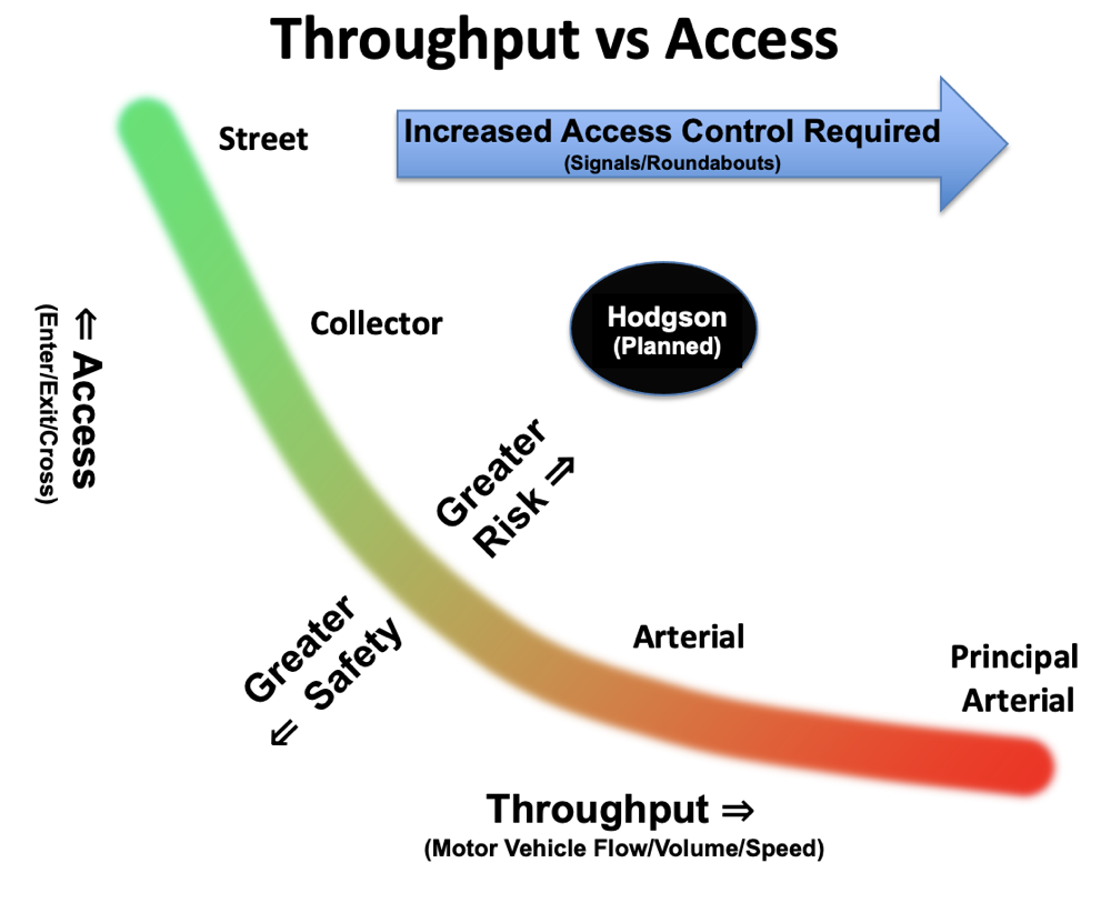
Throughput (traffic flow, volume and speed) is inversely proportional to Access (people needing to enter/exit or cross the flow of motor traffic). Junctions, intersections, commercial driveways, private residential driveways and ped/bike/disability crossings are all points of access. As Throughput is increased, Access is decreased. Or conversely, as Access increases, throughput must decrease.
You cannot safely have it both ways.
This plan for Hodgson is attempting to have high throughput in an area of high access which results in greater conflict and risk.
EVERY Access/Exchange is a Desire Line where someone, particularly children, will want to cross and will attempt to cross. Someone walking, riding a bicycle or with a disability and using a mobility device will always want to take the shorter and more direct route to wherever they are going. Someone leaving a house on Floral Ct to visit a friend across Hodgson on Floral Drive W will always want to cross Hodgson at the junction of these two streets, particularly in cold, rain, snow or darkness.
As Throughput increases the greater control that is necessary for safe access. A lower volume/speed Collector requires somewhat limited control – drivers entering/exiting and people wanting to cross can easily find safe gaps in traffic to allow them to do so. As traffic volume and speed increases so does the need for control such as stop lights to allow safe Access. Entering the flow of traffic or crossing it without a stop light becomes increasingly difficult and dangerous as throughput increases.
The more Access you’ll have the more often that drivers must be prepared to stop and that safe provision for crossing must be provided. These interrupt the expected continuous flow of an arterial. It’s important to note that drivers drive to the design of the road. A driver on a road designed as an arterial has a arterial/throughway mindset – they are in a continuous flow of traffic, are less attentive, and do not expect to stop nor are prepared to stop for anything until they encounter a stop light or a car in a roundabout.
It’s critical to understand that Access cannot easily be changed. People will desire to walk or bike the shortest distance between A and B. The many streets that intersect Hodgson through here are what they are and cannot practically be eliminated. Access can be ignored and made unsafe, as in this plan for Hodgson, but cannot easily be changed.
This concept is the foundational principle for the Functional Categories of Roads which is a critical element of safety (click for a larger image).
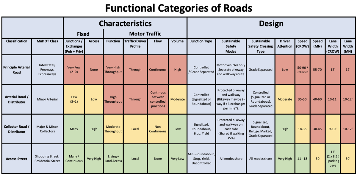
This is also sometimes called the Functional Hierarchy of Roads because it is intended to function as a hierarchy – and must do so to be safe. So Private Driveways connect to Access Streets which connect to Collector Roads which connect to Minor Arterial Roads which connect to Major/Principle Arterial Roads. Following this results in decreased access (junctions and crossings) as throughput increases and a balanced, low conflict, safe system. (Another critical element is driver mentality – driving for even a very short distance on a properly designed Collector changes their mindset from go-go-go to slower, more mindful and more cautious before they reach a residential street.)
Note that a key characteristic needed for an Arterial is few junctions/exchanges and low access as well as the need for controlled junctions and crossings at each. These requirements cannot be met along this section of Hodgson as there are too many public road junctions, institutional driveways and private residential driveways. The fixed environment of Hodgson has the characteristics of a Collector, not an Arterial.
A stated purpose of this project is “Improve pedestrian and bike access in alignment with Ramsey County’s All-Abilities Transportation Network plan. Pedestrian facilities will help connect users to parks, schools, churches and residential neighborhoods.” Yet this proposed plan is doing the opposite – increasing Throughput at the cost of safe Access.
Violating this basic principle, as is being attempted with this plan for Hodgson and resulting in what many call a Stroad, is a key reason for our highest among all developed nations crash, injury and death rates. Stroads such as this plan would build make up less than 15% of all roads but account for 67% of pedestrian deaths. It is a key reason why bicycle riders in the U.S. are 11x as likely to be killed as bicycle riders in safer countries and pedestrians an estimated 17-23x as likely to be killed.
…and was the reason for Reese being hit.
Exhibit B – Motor Vehicle Route Options
With rare exceptions, EVERY public road access/exchange/junction/intersection is a place where people walking, bicycling or with a disability will want to cross and each should be made safe for crossing. On an arterial an underpass is safest with a stop light next best. A properly designed roundabout can work in a few very low throughput situations though these are increasingly found to need underpasses both for safety and problems of waiting to cross. Those are the only safe options for crossing an arterial and every junction/intersection/side-road should have one as well as most commercial/institutional driveways. Ignoring this, as the current plan for Hodgson does and as the engineer who designed Birch did, is why incidents like Reese’s happen.
Similarly, each is also a place where drivers will need to enter/exit the roadway and, given the traffic volumes and speed of an Arterial, each of these usually needs a roundabout or signal to make this exchange safe.
Each one of these exchanges carries considerable risk, for drivers and for people walking or bicycling, that must be mitigated.
This short 1.25 mile section of Hodgson for this project has 13 public road accesses and 33 residential driveway entrances. For perspective, engineers of safer road systems will say that about 3 public and ideally zero private (residential driveway) exchange per mile is the maximum allowed if there is to be through traffic since each public exchange requires either signals or a roundabout and each private exchange on these roadways is dangerous for people entering and for people on the roadway. This section of Hodgson has over 3 times the recommended maximum of public and multiples of private.
Now let’s compare routes. From the junction of County Rd J / Ash Street and Hodgson Road (The new Lyngblomsten) to downtown St Paul there are two viable options; Hodgson to 694 to 35E and County Rd J / Ash Street to 35E. A driver taking the Hodgson route will encounter 53 public exchanges and 101 private driveways. Each of these comes with risk for the driver as well as anyone accessing the exchange to cross or enter the flow of traffic. If this driver takes County Rd J instead they encounter 11 public and 54 private so 1/5 as many public and half the private. That is a much safer route for everyone.
More importantly, the Hodgson route has few or zero opportunities to reduce public or private exchanges to make it safer while the County Rd J route has numerous. As an Arterial Hodgson will always be a mis-categorized and dangerous high-conflict roadway. On the other hand, County Rd J / Ash Street more closely matches the characteristics of an arterial, is much safer for everyone and with less negative impact on local residents to begin with, but importantly has numerous opportunities to further reduce risky access/exchange points so that it can function better and safer as an Arterial for through traffic.
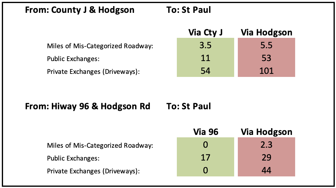
From Hiway 96 and Hodgson there are 12 public exchanges on the Hiway 96 route vs 21 for the Hodgson Route. Hiway 96 is also a somewhat proper Arterial and designed for through traffic so besides many fewer accesses there is overall much less risk and negative impact vs the Hodgson Route.
One other element here is pollution (and fuel consumption). Each time a car is stopped/started/slowed/speeded or idled waiting-in-line results in extra air (and noise) pollution and often significantly more, especially nitrogen oxides. The more exchanges, the more often that a car will need to change speed for a signal, roundabout, car pulling out in front of them or someone crossing the street, the more pollution produced. There are two concerns with this. One is pollution produced in the general area such as the city of Shoreview or Twin Cities Metro and the second is local pollution nearby a junction that directly affects people and homes within about 400 feet.
Do we want to encourage drivers to use Hodgson? Or the much safer and less negatively impacting routes?
Exhibit C – Safe Routes To School
What does this design for Hodgson do for providing a safe route to school?
Isabella will be starting at Chippewa Middle School soon after this project is complete. When she leaves her house on Floral Ct east of Hodgson to bicycle to school she’ll face two choices when she arrives at Hodgson;
Option 1: Cross Hodgson to get to the multi-use path on the other side.
Similar to the junction where Reese was hit Isabella will face a 60-70’ crossing of 3 lanes of high speed traffic. There are no signs or markings to tell drivers that this is a crossing. There is no refuge island so she has to make the full crossing of all three lanes and cars approaching at speed from multiple directions at once. Much of the traffic she’s facing off with will be through traffic – drivers just like the driver who hit Reese – not expecting to stop until they encounter a stop light.
People facing similar or narrower crossings of Hodgson north of Hiway 96 say that it’s like playing Frogger – except in real life with real lives at stake.
Option 2: Ride north on the sidewalk to a marked crossing with a refuge island or to the signalized junction at Snail Lake.
Ostensibly a safer route. But people walking, especially those using a walker or similar assistive device or pushing a stroller, don’t like people riding bicycles on the sidewalk – for very good reasons.
Conflicts between people walking and bicycling is a problem on similarly designed sidewalks along Hodgson north of 96 and elsewhere throughout Ramsey County. The area of this project south of 96 has a much higher population density and so a greater number of people contending for limited sidewalk space.
Should Isabella and her friends be riding on this sidewalk? What will they do after they’ve been yelled at a few times for doing so? Choose to play frogger with inattentive drivers and cross at Floral?
What options are we, the adults, providing her? Get yelled at for riding on the sidewalk or risk your life crossing with no protection?
What happens when these kids all have e-bikes and e-scooters that go 20 MPH on the sidewalk?
This is planned and engineered conflict. That’s not a good plan.
This is only the first of numerous risk encounters and decisions that Isabella and her friends will be forced to make as they navigate this proposed design. These are not decisions that children elsewhere have foisted on them and we should not be placing these burdens on our own children.
A Safe Route To A Friends House?
What happens when Isabella wants to walk or bicycle to see her friend who lives on Lilac Lane on the other side of Hodgson? Does she risk crossing at Floral Ct or Lilac Ln? Does she walk or ride the extra 1/4 mile north to a marked crossing and then back south?
Where she wants to go, the route she wants to take, is called a Desire Line. She, and others, will want to cross at Floral or Lilac. But this design makes both extremely dangerous. And much more dangerous than they are today. Interestingly, both are also, by Minnesota Law, legal crossings.
Or she wants to go to her friend’s house on Virginia Circle. A tougher choice that we’re forcing on her. The normal route would be to cross Hodgson at Floral, Demar, Hanska or Virginia. But these are quite dangerous. Does she go down to the roundabout to cross? How safe is that given the geometry and traffic volumes?
Should we be forcing children to make such life and death decisions? We are the adults. Shouldn’t we be making the decisions and providing a safe environment for Isabella and her friends so that when she’s in a hurry to get to school or excited to get to her friend’s house she doesn’t have to face such choices?
By the standards of most developed countries there is no safe place to cross Hodgson / Rice between Snail Lake Rd and South Owasso Blvd. Over 3 miles of impenetrable through road.
Exhibit D – Resident’s Experiences With Our Roads
Nextdoor.com is filled with complaints from people interacting with our dangerous-by-design roads. Here are two recent ones.
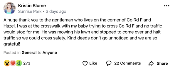
It should never be necessary for someone to require another person to stop traffic for them in order to cross a street. That road that Kristin was trying to cross is only two lanes and with slower speeds and less traffic than Hodgson.
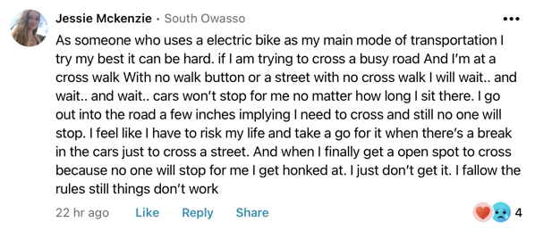
“Still things don’t work”. That’s an Engineering Failure.
Exhibit E – Health, Wellness and Welfare
We in the U.S. have the lowest life expectancy of all developed (OECD) countries. And we have the highest rates of many preventible chronic diseases. We also have the best healthcare in the world and we spend 2 – 4x as much on healthcare as other developed nations. Why this dichotomy?
Garbage in – Garbage out. Our bodies, physically and mentally, are not maintenance free. Our healthcare system cannot make up for the poor condition of the bodies we give it. We are not maintaining our bodies.
The key problem is lack of moderate daily physical activity*. We are too sedentary. We don’t move enough. The number one way for a population to successfully get this critical activity is Active Transportation – walking or riding bicycles for local (1-3 miles) transportation. To school, dinner, friends or the local grocery or pharmacy. We can encourage ‘exercise’ and ‘activity’ all we want but it has never worked – anywhere. People, whether Dutch, American, Costa Rican or Martian, don’t like to exercise. There is actually a bit of a reverse correlation between the number of gyms and health clubs in a society and it’s health.
Active Transportation requires a safe environment – safe infrastructure – walkways, bikeways, crossings and parking. Ideally built to CROW standards. Without a safe environment people cannot get this critical activity. While going to the gym, working out at home, and participating in active recreation are very beneficial, none of these has proven a solution anywhere. People will not do them consistently enough.
Given a safe environment people will walk or bike for local transportation (even in cold Minnesota winters).
Physical and mental health are co-dependent and also benefit from some of the same things. Walking or riding a bicycle to school or lunch not only provides physical benefit but mental and emotional as well. Anxiety created by living near a busy throughway such as the plan for Hodgson along with the car noise and air pollution created by such a throughway are bad for our mental and physical health. Anxiety created by trying to cross a busy throughway without a safe facility is bad for our mental health.
An engineer in Europe told me that they are increasingly preferring underpasses to signalized surface crossings of arterial type roads for numerous reasons but lower stress and anxiety for people walking and bicycling is one. They put a premium on things that lowers health problems. Which is why they live longer healthier lives while spending less than half as much on healthcare.
Financial stress has a detrimental effect on people’s mental health and by extension their physical health. An environment that requires driving a car for every journey including very short trips is an expensive society to live in. Replacing some trips with walking or bicycling reduces this expense and can reduce it significantly. Many young families are trying to go car-lite by having only one car and they look for communities where they can safely and comfortably walk and bike to local amenities. They also want their children to develop independence and their not wanting to be a taxi service to their kids plays in to neighborhood choice as well.
What about a route for a mom or dad to go to Kowalski’s or Big Dipper with their child? They will likely be riding a bakfiets or pulling a kid+grocery trailer. How will it go with either of these wider and less maneuverable bikes on a sidewalk as this plan requires? How much conflict is there likely to be? Is the planned refuge wide enough (and protected enough) for a child in a trailer to be safe from 50+ MPH traffic?
* Second is food. We eat too much, we eat too much junk food.
Exhibit F – A Better Alternative
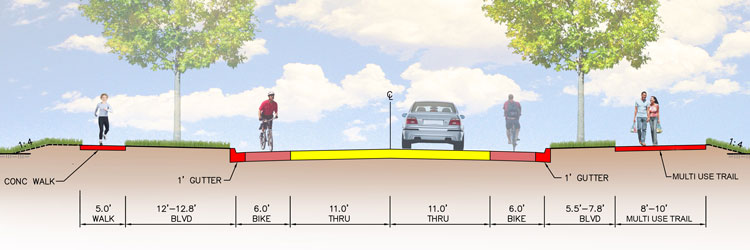
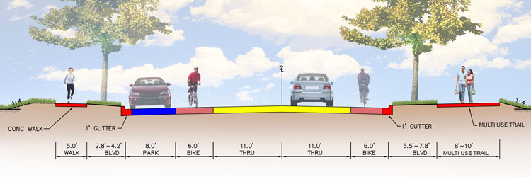
Following are comparisons of the Existing roadway, the Proposed roadway and how it would be built to CROW specs . House setbacks along Hodgson vary – this is using an approximate average. (yes, one lane is pointing in the wrong direction – an occasional abnormality of this app).
The proposed roadway places motor travel lanes about 6’ closer to houses on each side than the existing roadway. This plus extra contiguous asphalt will likely also result in considerable more noise.
Current Roadway:
Proposed Ramsey County Design that adds a traffic lane:
CROW:
The CROW plan is safer for all users, including people in cars, is quieter, places motor traffic farther from homes and yards, provides more yard space and more green space.
The proposed plan results in people riding bicycles, e-bikes (20 mph), e-scooters and monowheels on the sidewalk which is both dangerous and unpleasant. Built to CROW results in proper separation by speed, mass and direction.
Further References:
Crossing Hodgson is only one of numerous safety and other deficiencies with the current plan. A broader discussion is here: http://localmile.org/blog/2021/08/14/hodgson-anatomy-of-a-dangerous-road-design/
The U.S. has the most dangerous roads with the highest rates of crashes, deaths and serious injuries of all developed nations. And while other countries are reducing these, they are all increasing in the U.S. The reason for this is dangerous road designs like this plan for Hodgson. More on this at https://smartgrowthamerica.org/dangerous-by-design/
The Netherlands has had the safest systems for walking, bicycling and for those with disabilities for 45 years (and are among the safest for those in cars). Increasingly other countries and cities across North America are simply copying what they have done. The Dutch system is based on the CROW Principles of Sustainable Safety: https://swov.nl/sites/default/files/publicaties/rapport/dv3_en_kort_rapport_0.pdf
The residential streets in this area are important as well. http://localmile.org/reclaiming-our-residential-streets/
A similar project by Ramsey County resulting in unnecessary loss of trees: Cleveland Avenue – Failed Engineering.
For more on CROW road design principles and how they are implemented on a practical level: Bicycle Dutch.
Edits
2022.08.01 – Added Exhibit E

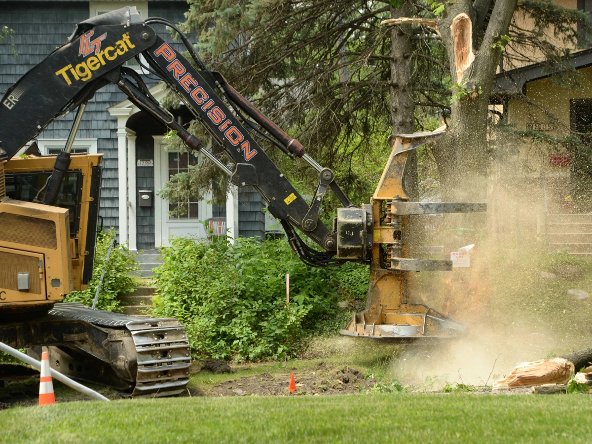
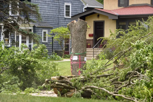 Tree removal along Cleveland Avenue a few months after I originally published this article. (Scott Takushi / Pioneer Press)